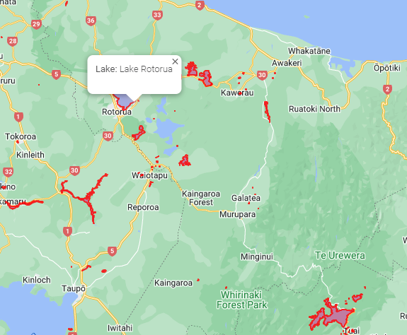
I managed to get this going with the following result
A New Zealand Lakes sample is on Github
You need to create a database and run this script which has the sample data in it.
The sample data is from LINZ and i used the following shape file importer Shape2SqlServer
I use a MS SQL geography field to store the data and a View to convert it to a Google Maps Polygon
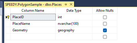
SQL Table
SQL View
create view [dbo].[vw_Places]
as
SELECT   REPLACE(REPLACE(REPLACE(REPLACE(REPLACE(Geometry.ToString(), 'POLYGON (', ''), '(', '[{lng:'), '))', '}]'), ', ', '},{lng:'), ' ', ' ,lat:') AS Area, PlaceName
FROM         Places
Here are the steps
- Add an Invoke data source method to the page to get the data from the view

-
Add a map to a page and get it working API Key etc
-
Add an Attribute Name @ref Value map to Google Maps Control

-
Open the project in your Code Editor
-
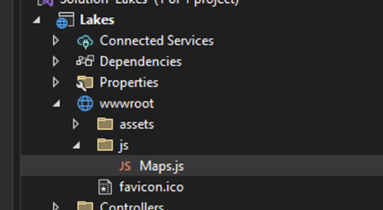
add the following JavaScript file "maps.js" to wwwroot/js
var map;
var polygons = ;
function initMap(UniqueID) {
if(map==null)
map = Radzen[UniqueID].instance;
}function drawPolygon( data, UniqueID,content) {
initMap(UniqueID);
var bounds = new google.maps.LatLngBounds();
const obj = eval(data);const shape = new google.maps.Polygon({ paths: obj, strokeColor: "#FF0000", strokeOpacity: 0.8, strokeWeight: 2, fillColor: "#FF0000", fillOpacity: 0.35, }); for (i = 0; i < obj.length; i++) { bounds.extend(obj[i]); } attachPolygonInfoWindow(shape,content);polygons.push(shape);
shape.setMap(map);northWest = new google.maps.LatLng( bounds.getNorthEast().lat(), bounds.getNorthEast().lng() );//Can add Marker
// new google.maps.Marker({
// position: northWest,
// map: map,//});
}
function attachPolygonInfoWindow(polygon, html) {
polygon.infoWindow = new google.maps.InfoWindow({
content: html,
});
google.maps.event.addListener(polygon, 'mouseover', function (e) {
var latLng = e.latLng;
this.setOptions({ fillOpacity: 0.1 });
polygon.infoWindow.setPosition(latLng);
polygon.infoWindow.open(map);
});
google.maps.event.addListener(polygon, 'mouseout', function () {
this.setOptions({ fillOpacity: 0.35 });
polygon.infoWindow.close();
});
}function clearMap(UniqueID) {
initMap(UniqueID);
if (polygons.length > 0) {
for (var i = 0; i < polygons.length; i++) {
polygons[i].setMap(null);
}
}
}
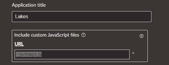
- In Radzen go to settings and add ~/js/maps.js to Include custom Javascript files
- Go to yourpagename.razor.cs and add the following code
public RadzenGoogleMap map { get; set; }
    // Waits for map to render
    protected override void OnAfterRender(bool firstRender)
    {
        if (map != null && firstRender)
        {
            var t = Task.Run(async delegate
            {
                await Task.Delay(1000);
                await DisplayLakesAsync();
            });
        }
    }
    private async Task DisplayLakesAsync()
    {

        //Clear the map first if you have realtime data

         //await JSRuntime.InvokeVoidAsync("clearMap", map.UniqueID);


        //Loop polygons and draw on map

        foreach (var lake in LakeResult)
        {

            // Popup text
            string content = $"<strong>Lake: </strong>{lake.PlaceName}<p><p><strong>";

            //Render polygons on Map using javascript

            await JSRuntime.InvokeVoidAsync("drawPolygon", lake.Area,  map.UniqueID, content);

        }


    }
- Run it